Skills and Techniques for the Arizona Trail

To experience the splendor of the desert in bloom, you must adapt to the scarcity of water
The Arizona Trail (AZT) winds through diverse environments including arid landscapes. Adapting to long stretches between water sources, coping with desert plants and temperature extremes requires unique skills and techniques. Navigation is also more challenging than on more mature and well traveled trails such as the Pacific Crest Trail (PCT) and Appalachian Trail (AT). Mastering water and navigation skills will empower you to feel more confident in arid conditions, and allow you to experience the unique beauty of the Arizona Trail.
1. Finding Water
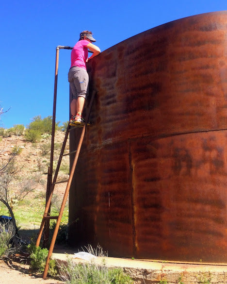
Unlike many areas where you can rely on natural waterways, the AZT depends on a network of natural sources (i.e. streams, springs and pools) and man-made sources (i.e. public caches, rancher-owned stock tanks and ponds). Since many sources are off-trail and other sources are hard to spot, finding water becomes a scavenger hunt. To get the cleanest water, you'll need to use sleuthing and puzzle-solving skills to decipher the maze of pipes, valves, and ladders ranchers have constructed to bring water to the surface for their cattle.
Tips:
- Follow directions on the water report and databook
- Learn the reliability scale for water sources (ratings from 0-4), and determine if you are hiking in a wet or dry year.
- Use waypoints downloaded to a GPS unit or phone app
- Trace piping from stock tanks to find upstream water sources to avoid stagnant cattle troughs

Climb ladders above stock tanks, depress float valves or turn knobs near stock tanks to get fresh water.
2. Managing Water
Long stretches of trail lack naturally occurring water sources, with many offering less than desirable water replete with algae, cowpies, floaties, and dead animals.
Tips:
- Determine mileage between sources
- Plan for adequate water vessel capacity
- Develop a clean/dirty vessel system to avoid cross contamination
- Use a scoop and prefilter to get water from shallow sources
- Have a method to treat water

How do you juggle 5-8 liters of water, let alone keep track of which water is untreated and which you've gotten fresh from a faucet?
4. Spine and Prickery Management
Beyond cactus, many thorny flora crowd the trail. You won't escape getting stabbed or pricked by these plant defenses, but you can wear protective clothing and be prepared to remove embedded spines.

Battling through overgrown trail.
Tips:
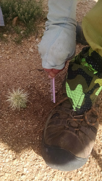
- Carry a comb for detaching cholla, and tweezers for removing spines
- Include benadryl and antibiotic ointments for spine reaction
- Wear snag-resistant clothing; consider full body armor
- Scan clothing and gear for spines before entering your shelter

Cholla cactus "jump" onto hikers; keep a comb handy for immediate spine removal.
4. Thermoregulation
Think the desert is always hot? Not true! Be prepared to adapt to constantly changing temperatures and a variety of weather extremes. Sure the heat of the day can rise into the high 80s and 90s, but then it can swing down into the 20s or 30s at night. The trail traverses elevations ranging from 1,700' to 9,600', with several thousand feet of elevation changes daily.

Down jackets, hats, and long underwear insulate against frigid mornings.
Tips:
- Prepare for heavy frost, rain, heavy wind, hail, snow and lots of sun
- An umbrella shields you from both rain and unrelenting sun
- Protect body from the sun with full body clothing, hat and high caliber sunscreen
- Drench clothing and hair for natural air conditioning (only when water is plentiful)

You just have to take it off to give it a good soaking

The initial shock of putting on our soaking wet shirts, before the cooling relief sets in.
5. Navigation
As a young trail, turn-by-turn signage is not yet fully developed. Verbage can be inconsistent as the trail passes through parks and various land management agencies. Some signs indicate the AZT while others only show the name of shared trails. Networks of cattle paths and rancher and ATV roads further create navigational confusion, as does the use of cairns in place of signage.
Tips:
- Carry topo maps and know how to use a map and compass
- Use the Arizona Trail Association's data book which includes written directions
- Download the AZT track and waypoints onto a GPS unit or smartphone app (i.e. Gaia or Trimble)
- Become proficient with any GPS/App technology (learn to use in airplane mode)

Which way is the Arizona Trail?
Conclusions:
You too can take your skills to the next level by rising to meet the water and navigational challenges of the Arizona Trail. Finding and carrying water on the Arizona Trail is challenging, but it's worth it to explore these incredible landscapes on foot. Using our navigational knowledge and experiences to successfully traverse the Arizona Trail between passages and water sources made us feel accomplished, because it wasn't just about following the blazes–the trail and obstacles were always engaging and kept us on our toes. We found it rewarding to stretch our abilities beyond our previous comfort zone.
This post was contributed by Trail Ambassadors Jan "Beekeeper" McEwen and Joan "Hemlock" West
