Paul's John Muir Trail Hike
My John Muir Trail Adventure
You know you've married the right girl when she says, "go for it, this'll probably be your only chance to hike it before you retire!", especially when you add the fact that she was committing to watching our four kids by herself for the two-to-three weeks that I would be hiking our dream hike.
It started as a joke back in 2012 on social media, that a few of us would hike the John Muir Trail the following summer. Don't get me wrong, I knew about the trail and I was bewitched by the idea of disappearing into the Sierra Nevadas for a few weeks of hiking, especially having seen the photos, but I just never thought I'd get the chance.
A year later, after many hours of planning logistics, organizing food, buying outdoor gear, and cutting unnecessary weight, I pulled an all-night drive down to California (from Seattle). Fueled by nerves, beef jerky, candy and Doctor Pepper (lots of Doctor Pepper) I arrived at the bus stop, ready for the last leg to Yosemite Valley.
I'd never been to California, or Yosemite for that matter. Being the last child one tends to miss out on those family adventures. If you haven't been, I heartily endorse making the trip down there to do some hiking.
My first day had me climbing the Mist Trail up towards the Half Dome. After spending the previous day on the hot, dry valley floor, the cool, moist air coming off the falls gave me life and buoyed me on as I hiked the 8 miles up to the base of the Half Dome.

Half Dome
The photos and videos of the Half Dome didn't really prepare me for the experience. The rock between the rails is polished smooth by the hundreds of feet that daily make the ascent. One relies on their upper body strength to do a lot of the work. That said, it's easier coming down. I even found myself walking down on the outside of the railing to avoid the traffic and get better traction.

Tuolomne Meadows Stars
Two days after leaving the crowds in the Yosemite Valley, I was in Tuolomne Meadows. While there were still a lot of people there, once you were heading up the valley, I hardly saw anyone. After leaving the lights of civilization behind, the night sky started to explode with stars.
The trail was incredibly well maintained, and yet not overly modernized. Most river crossings were simple log bridges. Only when you hit the more populated areas of the park do you encounter "real" bridges. It was near one of these bridges that we met an eighty-four-year young lady that had hiked the John Muir Trail several times previously and was now taking her own children with her for her last trip. Her "kids" were in their sixties themselves.

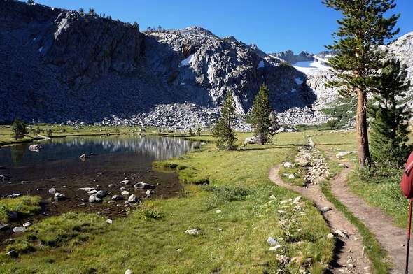
Path Water
Before heading out on the trail I was told that every day and every pass would show me something new. That person, whoever they were, was right. Each ridge and valley brought amazing views. Sometimes the beauty was in the subtle details, but often I was just stunned by profound changes from one ridge to the next. One thing that did stay the same was how blue and clear the water was. I'm pretty sure I took a photo of every lake that we passed on the way.
There's plenty of water on the trail, even in late July. We'd usually drink a liter or two at a place like this and then load up for the next 5-10 miles.
Despite the miles we were putting in (15-22) each day, we had plenty of time to take photos, relax and contemplate the adventure.

Lake Reflection
We camped near Garnet Lake, where the fishing was decent and the views were incredible. I had to be pulled away from this view the next morning so we could get through Red's Meadow.
This shot is one of my favorites of the trail. With the help of a buddy Chris, I did a couple time-delay shots. I'm not an artsy type, as you've probably noticed, but this picture encapsulates the blur of the hike. It went by so quickly, but strangely, at the same time, was relaxing and peaceful. Juxtaposed.

Sushi
To make up for the lack of space in my bear canister (we had one refill in two weeks) I took to fishing with my Tenkara fly rod. I caught a lot of fish, but at Virginia Lake I pulled out a big enough trout to turn into trail sushi (complete with ginger and wasabi). This was probably one of my favorite meals of the whole trip and was a refreshing change from freeze-dried meals.
Read part 2 of this amazing adventure!

Alpine Lake
The night we camped near this lake a storm front came through with lightning and thunder. The following evening, this same storm blew down one of the team's tent and flooded it. All of his down gear (including sleeping bag) was soaked. We spent the next morning vainly trying to dry out gear.

Muir Hut
Built over 70 years ago, the Muir Hut is a work of art. It was constructed on a pass, in the middle of nowhere using stones from the site and concrete mule-packed in from miles away. We took shelter from another surprise storm front before deciding to hike down off the mountain to a more protected site.
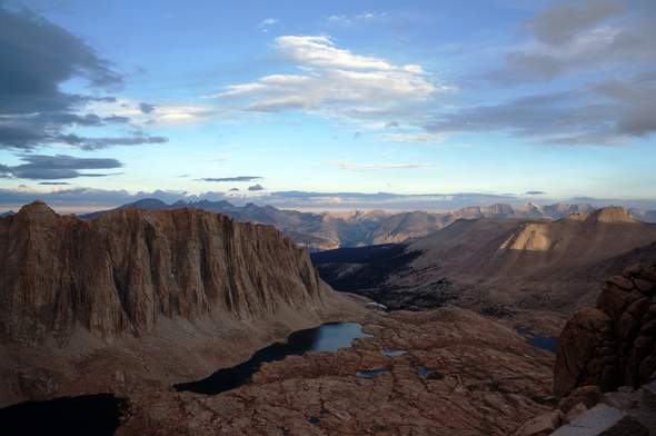
After a depressingly cold night and foul weather for three days, I rounded the corner to see this beam of light cutting down through the middle of a swirling cloud. It was the day before we hiked Whitney and it really lifted my spirits. I had been feeling down about the trip ending, but from then on in I had an inexplicable energy that drove me onward and upward.

View from Whitney
As most people do, we camped at Guitar Lake below Whitney. The weather was fickle. One minute there'd be clear skies and the next it was spitting rain. We got an early night as although it was only 8 miles or so to the "end" of the John Muir Trail on Mount Whitney it's another 8 from there to the parking lot.

On Whitney
With the wind whipping ice crystals across my face, and thunder clattering around me, I made it to the highest point in the lower forty-eight: Mount Whitney. After this obligatory photo we all rushed into the shelter… when I say ALL, I mean an entire Boy Scout troop plus a handful of day trippers and JMTers. There was standing room only in the cramped stone hut (which was plastered with warning signs stating that the building did NOT protect from lightning strikes).
I didn't really have time to reflect on the trip until we were off the mountain. Once down from the summit, the next two to three hours to the portal felt like an eternity as I detangled my thoughts from the past sixteen days.
On that trip of over 212 miles I took over a thousand photos and around 10 hours of HD video, I wore out a pair of shoes, caught dozens of fish, downed about 75000 calories, lost 15 pounds, spent two nights in a monsoon (lightning striking all around my tent), and summited the highest peak in the lower 48. Reviewing it all now, six months later, it feels like a lifetime ago, and yet browsing through those photos and videos I'm immediately re-immersed in the sights, smells and emotions of those 2 weeks. I can echo my own cheesy words from the end of the trail:
It's been quite the incredible trip and definitely, if you haven't, you need to get out and enjoy that trail, because it's one of a kind.
Enjoy my video from this backpacking trip
This post was contributed by former Trail Ambassador Paul Osborn.
