
Beauty, Adventure, & the Right Gear on an Off-Trail Grand Canyon Route
The Grand Canyon is my favorite place of all - the more I see, the deeper appreciation I have for this Wonder of the World. I am currently working on traversing the length of the Canyon in sections. The Colorado River through the Canyon is 277 miles long, but once I'm done I will have hiked over 600 miles.

Photo: Redwall Overlook - Tanner Trail
The extra miles are from weaving in and out of side canyons, hiking in and out for access, and changing from one layer of travel to another. To date, I've completed 71 river miles. One of my favorite parts of this project is that there are often several routes to choose from, depending on what my preferred line of travel is and what I want to see. So the first step is deciding which route to take.

For this week-long solo trip, I hiked from the Nankoweap Trail on the North Rim to the Tanner Trail on the South Rim. I had a couple of options after descending Nankoweap: the river route, which is what the Hayduke Trail uses, or the Horsethief/Butte Fault Route. Each had its challenges.
The river route sounds like it might be a stroll along the beaches, but in reality it is often a thrashfest through shoreline tamarisk and thorny mesquite and acacia, combined with travel on the rocky slopes above, contouring in and out of countless small ravines and drainages. The Horsethief/Butte Fault option was more strenuous and logistically challenging due to having to climb and descend numerous passes and a dry camp, but has unique geology on a historic route. Both routes require a boat shuttle across the river (or a packraft if you're so inclined).

Photo: Thumbing a ride across the Colorado River
The Butte Fault, which contributes to the depth of Grand Canyon, creates a weakness in the layers that allows travel behind a series of buttes and side canyons. This route was used first by Native peoples, then by rustlers moving their stolen horses from one rim to another, and also by miners and cowboys. I used to work as a river guide and had floated by the river route over 20 times, plus I'm a huge geology, archaeology, and history geek, so I chose the 41-mile Horsethief/Butte Fault Route.

Photo: Kwagunt Butte shows the uplift of the Butte Fault
All the research, permits, and a shuttle fell into place and I started my hike at the upper Saddle Mountain Trailhead on October 16th. The Nankoweap Trail is billed as the hardest named trail in the canyon, due to its 6,000-foot descent and exposure. There are spots on the trail where travel is between a cliff and a sheer drop and others where the trail is thin, steep, exposed, and covered in ball-bearing gravel. After my night at Nankoweap Creek, I was off-trail until I reached the Colorado River on day 4.

Photo: Saddle Mountain Trailhead
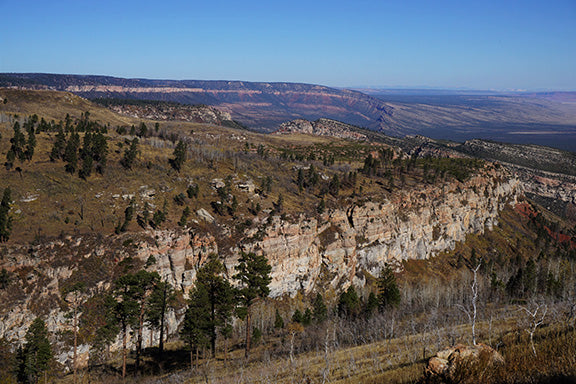
Photo: Edge of the Kaibab Plateau

Photo: First glimpse of the inner Canyon
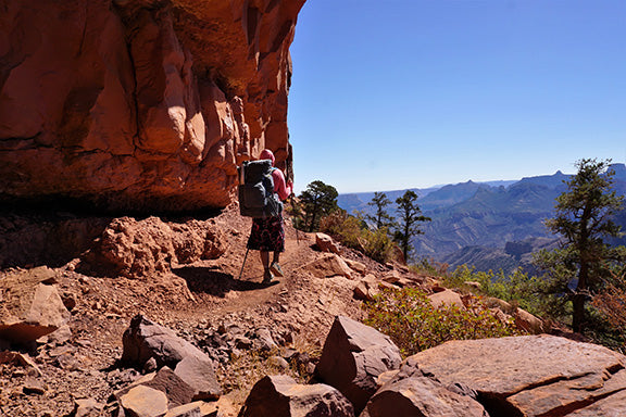
Photo: Nankoweap Trail
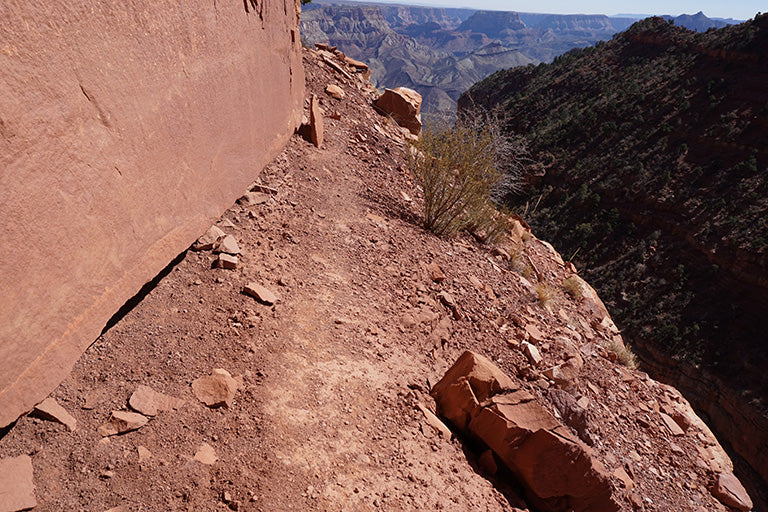
Photo: Nankoweap exposure

Photo: Butte Fault

Photo: Thin trail in the Bright Angel Shale
The Horsethief/Butte Fault Route ascends and descends the fault line through a series of six side canyons: Kwagunt, Malgosa, Awatubi, Sixtymile, Carbon, and Lava/Chuar. The climbs and descents ranged from 500-1,600 feet each. It was a fun puzzle to pick a line of travel in and out of each one. I spent my next night at Kwagunt Creek, temperatures were in the 40's at night and the 80's during the day, any hotter and I would have had to take the river route instead.

Photo: Nankoweap Creek

Photo: Nankoweap camp sunrise

Photo: Hiking up to the Nankoweap-Kwagunt divide

Photo: Tilted Supergroup Strata
The next morning, I loaded up with nine liters of water for a dry camp. Nine liters added twenty pounds to my Mariposa, but as long as I took regular breaks with it off, it wasn't too uncomfortable. The star of the show this trip were my LT5 trekking poles, I couldn't imagine it without them. The terrain was often steep and loose and with the extra weight in my pack, the poles helped to keep me stable.

Photo: Nine liters of water -ouch!

Photo: Looking back at Nankoweap Butte

Photo: Off-trail Terrain
Navigation was made a bit easier by the fact that I could study the next line of travel while coming down the opposite side of the canyons. I only made one mistake, turning left too early coming out of Malgosa Canyon and ascending a steep and loose chute that put me above the saddle I was aiming for. A sketchy traverse got me to where I needed to be to continue. I passed a historic coffee pot on the route before spending night 3 in Awatubi Canyon.

Photo: Artifacts from Ancient Travelers
The next day, I had 4.5 liters remaining and had eaten most of my food, so my pack was quite a bit lighter. I had friends place a bucket cache at the Colorado River for me so that I didn't have to carry the full week's worth of food on top of all my gear and water for a dry camp. It was overcast and cooler which helped on the climbs. The Butte Fault creates a spectacular bending and uplift of the layers, it was one of the most interesting parts of the Canyon I'd been to so far. This is what I love about the place, you could explore every day for the rest of your life and never run out of amazing sights to see.

Photo: Hiking up to Awatubi-Sixtymile Saddle
I hiked in and out of Sixtymile Canyon, reaching the saddle with the East Fork of Carbon Canyon and my first views of the South Rim in days. The familiar buttes and temples were a welcome sight. There was a small piece of historic trail construction on the descent down Carbon.
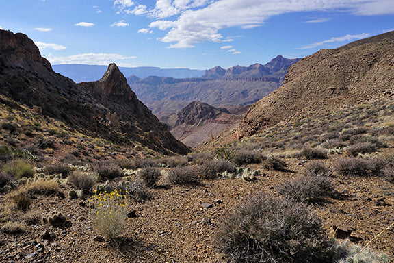
Photo: Views to South Rim from Carbon Saddle

Photo: Historic Trail Construction
Several bypasses to avoid steep pouroffs in the bed of the drainage were required, typical Grand Canyon. Eventually the obstacles ended and it was just a pleasant walk in a streambed. I picked up a river runner trail between Carbon and Lava/Chuar Canyon and reached the Colorado River around 2:30 in the afternoon. My concerns about water were over!

Photo: Micro Chicken in the Carbon Canyon Narrows

Photo: Hiking to Lava Chuar
I located my bucket cache with my food for the next three days and some treats like coconut water and a can of mandarin oranges. I kept my eyes peeled for boats, I needed a ride across the river so I could continue my journey on the south side. It was a spectacular sunset and I spent the night doing light painting and enjoying the sounds of the rapid.

Photo: Lava/Chuar Sunset

Photo: Party Lights!
On Day 5, I waited for a boat that never came. It was surprisingly enjoyable - I had enough food and water to wait and made the most of the day. My own personal beach in the Canyon.

Photo: Truth.
After waiting 44 hours on the beach, I finally spotted boats at 10:30am on Day 6 and enthusiastically waved them over. I was so happy to see them and they were curious about where I'd come from. I rode through the rapid and got dropped off on the beach. The rafters took my bucket and my garbage out with them, they were the first people I'd seen since noon on my first day. I hiked the Beamer Trail west to the Tanner Trail and connected my line.

Photo: My ride across the Colorado River

Photo: I'm on a Boat
The hike out was awesome. Tanner Trail was fancy compared to the terrain I'd been on. I took most of the day, taking several really long breaks, and savoring every last second. I reached the rim feeling strong, fulfilled, and grateful that I have the ability to take on such an adventure. Each piece of the traverse brings its own challenges, and the rewards are spectacular.

Photo: Top of the Tanner Trail - success!
Off-Trail Grand CAnyon Gear List
Here's my gear list for this trip. Read more details about this trip and my other adventures at Sirena's Wanderings or on Instagram at @desertsirena.

Photo: Grand Canyon Horsethief/Butte Fault Gear
| Item | Weight (oz) | Notes |
|---|---|---|
| Backpack | ||
| Gossamer Gear Mariposa 60 (medium with hipbelt) | 32.7 | |
| RikSak 17 packable backpack | 5 | |
| Shoulder Strap Pocket (Large) | 1.5 | |
| Trash compactor bag liner | 1.5 | |
| Shelter/Sleeping System | ||
| Gossamer Gear The One | 22 | Carried, not used - I slept under the stars |
| Titanium tent Stakes (6) | 1.8 | |
| Gossamer Gear/Klymit 3/4 length inflatable pad | 12 | No longer available |
| Gossamer Gear Thinlite Foam Pad | 2.5 | |
| Western Mountaineering Ultralite 20 degree | 29 | |
| Exped pillow UL (Large) | 2.1 | |
| Large Polycryo groundsheet | 3.6 | |
| Kitchen | ||
| Snow Peak Gigapower Stove | 3.7 | |
| Gossamer Gear Bamboo Spoon | 0.5 | |
| Snow Peak Titanium pot (not pictured) | 5 | MSR pot in photo |
| Ursack | 6 | Lots of mice and ravens in Grand Canyon |
| Hydration | Dry camp required lots of carrying capacity | |
| Platypus 4L gravity filter | 11.5 | |
| 3L Platypus hoser | 3.8 | |
| Platypus shutoff valve | 0.2 | |
| 2L Platypus (2) | 2.6 | |
| LIFEWTR Bottle | 1 | |
| First Aid/Hygene/Repair | ||
| Personal Hygiene (Glasses, soap, toothbrush/paste, mirror/brush) | 4.5 | |
| Toilet Kit (Deuce of Spades, TP, hand sanitizer, wipes, baggies) | 4 | |
| First Aid Kit (list below) | 12 | |
| Epi Pen | ||
| Tweezers | ||
| Vet wrap | ||
| ACE bandage | ||
| Sawyer Sunscreen | ||
| Trail Toes (anti-chafe) | ||
| Lip Balm | ||
| Rubber gloves | ||
| Band-Aid Blister Bandages | ||
| Steri-strips | ||
| First aid cream | ||
| Band-Aids (multiple sizes) | ||
| Glacier Gel | ||
| Needle and thread | ||
| Pinyon cream | ||
| Medications (Ibuprofen, Benadryl, Pepto-Bismol, Immodium, Allegra, emergency Percoset) | ||
| Clothes | Temperatures ranged from 40-80 degrees | |
| Thrift store skirt | 7 | |
| Columbia Fleece tights | 6 | |
| Shorts to wear under skirt | 2 | |
| Columbia Fleece pullover 1/4 zip | 5 | |
| Marmot Precip rainjacket | 9.6 | |
| Silk scarf | 0.1 | |
| Fleece Gloves | 0.5 | |
| Gloves for brush | 2 | |
| Thrift store button-up shirt | 3 | |
| Underwear (2) | 2 | |
| Injinji liner socks (2) | 2 | |
| Darn Tough long socks | 2 | |
| Knit warm hat | 1 | |
| Mountain Hardwear Ghost Whisperer (hooded) | 7 | |
| Xero Z-Trail camp shoes | 9 | |
| Bandanna | 0.5 | |
| Electronics | ||
| Garmin InReach Explorer | 5 | |
| Sony A6000 camera with 16-55mm lens | 16.5 | |
| Anker rechargeable battery (PowerCore 13400) | 10.7 | Night photos take lots of battery |
| Iphone 5S with LifeProof Nuud case | 4.5 | Used Gaia for mapping and GPS |
| Sansa Clip Mp3 and earbuds | 1.5 | |
| Black Diamond Spot Headlamp | 3.2 | |
| LED camp lights | 4 | Campsite lighting and photography |
| Extra camera battery, lens cleaning kit, extra SD card, USB cords | 4 | |
| Miscellaneous | ||
| Gossamer Gear Umbrella | 8 | |
| Gossamer Gear LT5 3-piece trekking poles (2) | 9.2 | |
| Tripod | 12 | For long-exposure night photography |
| Gossamer Gear Swiss Army knife | 0.8 | |
| Notebook, pens and maps | 4 | |
| Cuben Q-Storage Sacks (small and large) | 0.5 | |
| Micro Chicken, my faithful adventure companion | 0.1 | |
| Base Weight | ||
| Total (oz) | 311.2 | 19.5 lbs. |
| Clothes Items/Worn | ||
| Columbia Just Right Pants | 9 | Pants for off-trail, skirt for on trail |
| Stonewear Sun hoodie | 8 | |
| Dirty Girl Gaiters | 0.5 | |
| Altra Olympus (size 10) | 24 | |
| Scunci visor | 1 | |
| Buff | 1 | |
| Injinji liner socks | 1 | |
| Point 6 socks | 1.5 | |
| Sports Bra | 4 | |
| Sunglasses from Target | 0.5 | |
| Patellar Tendon straps (2) | 2 | |
| Total Worn (oz) | 52.5 | |
| Total worn and carried (oz) | 363.7 | 22.7 lbs. |