World Famous Rainbow Bridge Trail
One of my all-time favorite backpacking trips is the Rainbow Bridge North Route Trail. It's remote, rugged, challenging, and very, very scenic. The hearty souls that walk this route see epic panoramas, breath-taking views, historic ruins, chiseled canyons, and beautiful desert riparian areas.

Rainbow Bridge
About the Hike
Less well known that the South Route, the North Route is also on the Navajo Nation. The trail is located in Utah just north of the Arizona border northeast of Page, AZ. The trail is approximately 19 miles, depending on how close to the trailhead you get on the very rough access road, and has about 3,500' accumulated elevation gain. The path traverses the northern flank of rugged 10,200' Navajo Mountain. The trailhead elevation is 5,350' and the hike ends at Lake Powell's Rainbow Bridge at 3,750'.
Interested in learning more about this route? Make sure you check out the next part.

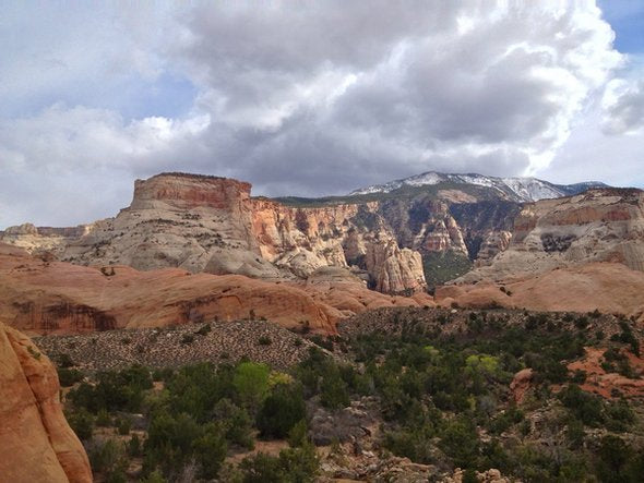
Cha Canyon
Compared to the South Route, the North Route is considered more scenic, has more water sources, and has more camping options. I've hiked a lot of great places and this one's definitely in my top 3 very favorite treks. I'm a huge fan of colorful sandstone canyons and also like remote, wild places. This hike offers the very best of both. The trailhead is as remote as any place you're likely to find in the lower 48 states. Don't expect to see any other hikers on this trail until the very end at well visited Rainbow Bridge.
Some of the hike is more route than trail and careful attention is needed to avoid getting off track. There are no sign posts and only one trail junction. Frequent cairns are very helpful. The trail was built by local guides with limited resources so it's very different construction that what you're probably used to seeing. The trail varies from flat slickrock, to rocky tread, to loose sand. Many of the climbs into and out of the side canyons are very steep with one almost a class 2 climb.
The best time of year to do the hike is mid-March and April. Expect snow in the winter, excessive heat in the summer, and limited water sources in the fall.
Three Options to Hike This Trail
All mileage is from the official trailhead. Add 1 - 2 miles for the rough road unless you bring a high-clearance 4-wheel drive vehicle.
The easiest way to hike the North Route is to do an in & out hike over 3 – 5 days. While the trailhead is difficult to find, this option eliminates the need for a shuttle. For a great 3 – 5 day trip. It's recommended to hike in to Bridge Canyon to set up a base camp (mile 11.5, 1 -2 days) then day hike (12 miles RT) to the Bridge and back.
Another option is to hike in on the North Route and out on the South (Rainbow Lodge) Route, setting up a car shuttle between the two trailheads. This is a 40 mile trek that would take 4 – 7 days. It's a good idea/courtesy to ask permission from the local Navajos for permission to park your vehicles. A small fee to watch your vehicles is appropriate.
But the way I do this trail is to leave our vehicles at Lake Powell's Wahweap Marina outside of Page, AZ and hire a shuttle to take us to the trailhead. Then, after 2 – 3 days of hiking, when we reach Rainbow Bridge and Lake Powell, we hire a boat to take us back to the marina. The 2 hours boat ride though spectacular Lake Powell is amazing. Total cost for the camping, permits, shuttle, and boat ride in April 2014 was $180/person.
Only hikers that are very strong, experienced, and that go ultralight should attempt this route in 2 days. There's a lot to see and explore so don't hesitate adding an extra day or two.
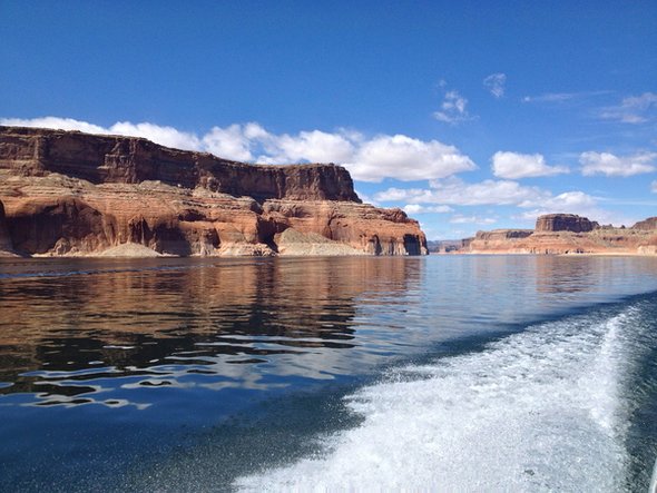
Lake Powell Boat Ride
Logistics
As you'll be right on the Arizona/Utah border, be sure to specify the time zone when making plans.
I use Betty Price at End of Trails Shuttle (928-355-2252) to drive us the 2 hours to the trailhead. The route goes through some remote Navajo land and it's a very scenic drive. Betty stops at the historic Inscription Rock Trading Post for one last stop before dropping you off near the trailhead. Call Betty for current pricing. Cash only. The access road gets worse the closer you get to the trailhead so you'll need to plan to walk the final 1 to 2 miles. There is no water or facilities at the trailhead.
Permits must be obtained from the Navajo Nation Parks and Recreation Department.
The cost is $5/day to hike and $5/night to camp. Allow 6+ weeks for processing if requesting by mail. Payment is by money order only. Permits can also be more easily obtained by stopping in Page, AZ at the Antelope Canyon office.
The boat ride is arranged through Wahweap Marina (888-896-3829). Call and reserve "backpacker" one-way tickets. You will need to plan to be at Rainbow Bridge on a day and time that the tourist boat will be there. The boat runs infrequently in the spring so make this step one of your trip planning. If you have 6 – 7 people in your group, it may be more economical, and give you more flexibility, to charter a private boat through marina's Executive Services.
Pre-trip camping is available at Wahweap Campground, just a short distance from the marina and the shuttle meeting location. Laundry and showers are available at the campground store.

The Hike
The trailhead is the end of the road with a small circle turnaround area. After 1 mile, the trail drops into beautiful Cha Canyon. We usually plan to drop our packs here and day hike downstream. About a half mile down on the right is a small Anasazi cliff dwelling. This is a great canyon to explore so take your time and hike 2 – 4 miles down canyon.
At mile 3.5, you drop steeply into Bald Rock Canyon which makes a nice first camp on a 3-day trip. There is reliable water here in the Spring months. After climbing up and out of the canyon, you'll have great views of scenic Navajo Mountain and will pass an old deserted Navajo hogan. It's fun to stop and respectfully view the old structure and ponder Navajo life of yesteryear.
The hike between Bald Rock Canyon and Oak Canyon offers both challenges and breath-taking views. At mile 6.5 Surprise Valley/N'asja Creek makes a nice camp with reliable water. At mile 7 you reach Owl Bridge on the left – a large natural sandstone bridge. I often have to look back to see it so it's easy to miss. The toughest climb out of a canyon is at mile 8. The trail seems to go almost straight up and is sketchy in spots.
Oak Canyon, with the most reliable stream, is at mile 10. Camping space is limited but there's room for 2 – 3 tents. For a small group, this would make a great place to stop. The climb out of Oak Canyon is long and steep. The trail goes up and down strenuously for the next 1.5 miles before dropping down on a rocky trail into the pretty Bridge Canyon with lots of trees and places to camp. There's a great site about 150' past the creek crossing.
The trail follows the creek in Bridge Canyon through a very scenic riparian area with towering canyon walls for the next 4.5 miles. At the junction with the South Route trail at Redbud Creek, the trail veers to the right to go to Rainbow Bridge. There is lots of good camping here and reliable water. After a mile or so as Redbud Canyon begins to narrow, the trail climbs up to the right and stays high. This is an easy turn to miss as you're walking on slickrock.
The trail passes a couple of gates and rounds a large side canyon at Echo Camp and suddenly awe-inspiring Rainbow Bridge comes into view. The best photos are taken from this vantage point. It's pretty cool to be able to walk underneath the massive arch and realize that no photo can capture its grandeur. It's another half mile to Lake Powell and the boat docks. Restrooms are available there.
If you ride the boat out, know that the wind will make the ride chilly. Use full sun protection (sun screen, hat, sunglasses, etc).

Final Thoughts
If you're planning a vacation in the Southwest, this is a great hike to combine with Buckskin Gulch, a visit to the Grand Canyon, or to Zion National Park. It is strongly recommended that you bring maps and a loaded GPS. Know that Navajo Mountain is big enough to make its own weather so prepare for unexpected weather regardless of the forecast. Don't underestimate the challenges of this hike. It's a great trip but give yourself sufficient time to explore and enjoy the journey.
Resources
Here's a map and GPS waypoints
Here's the NPS write-up and directions to the trailhead
This post was contributed by former Trail Ambassador Dave "Lucky" Brunstein.